Податотека:NovoLisice.jpg

Големина на овој преглед: 587 × 600 пиксели. Други разделности: 235 × 240 пиксели | 470 × 480 пиксели | 752 × 768 пиксели | 1.002 × 1.024 пиксели | 2.005 × 2.048 пиксели | 3.000 × 3.065 пиксели.
Изворна податотека (3.000 × 3.065 пиксели, големина: 3,5 МБ, MIME-тип: image/jpeg)
| Ова е податотека од Ризницата на Викимедија и може да се користи на други проекти. Подолу е наведена содржината на нејзината описна страница.
|
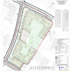
| Опис | The graphical scheme of the Detailed urban plan for a settlement (urban area A) within the Aerodrom municipality of the city of Skopje, Republic of Macedonia. The graphical scheme contains different zones which are designated with different colors in the graph on the right side of the photo. | |||
| Датум | ||||
| Извор | [1] | |||
| Автор | Council of the Municipality of Aerodrom | |||
| Дозвола (Повторно користење на податотекава) |
|

![[1]](http://www.aerodrom.gov.mk/Images/dup/NovoLisice.jpg)
Историја на податотеката
Стиснете на датум/време за да ја видите податотеката како изгледала тогаш.
| Датум/време | Минијатура | Димензии | Корисник | Коментар | |
|---|---|---|---|---|---|
| тековна | 10:54, 3 април 2010 | | 3.000 × 3.065 (3,5 МБ) | Модернист | {{Information |Description=The graphical scheme of the Detailed urban plan for a settlement (urban area A) within the Aerodrom municipality of the city of Skopje, Republic of Macedonia. The graphical scheme contains different zones which are desig |
Употреба на податотеката
Податотекава се користи во следниве 4 страници:
Глобална употреба на податотеката
Оваа податотека ја користат и следниве викија:
- Употреба на an.wikipedia.org
- Употреба на bn.wikipedia.org
- Употреба на en.wikipedia.org
- Употреба на es.wikipedia.org
- Употреба на fr.wikipedia.org
- Употреба на ha.wikipedia.org
- Употреба на hu.wikipedia.org
- Употреба на ja.wikipedia.org
- Употреба на ml.wikipedia.org
- Употреба на no.wikipedia.org
- Употреба на sr.wikipedia.org
- Употреба на vi.wikipedia.org
- Употреба на www.wikidata.org
- Употреба на zh.wikipedia.org