Податотека:Breakup of Yugoslavia.gif
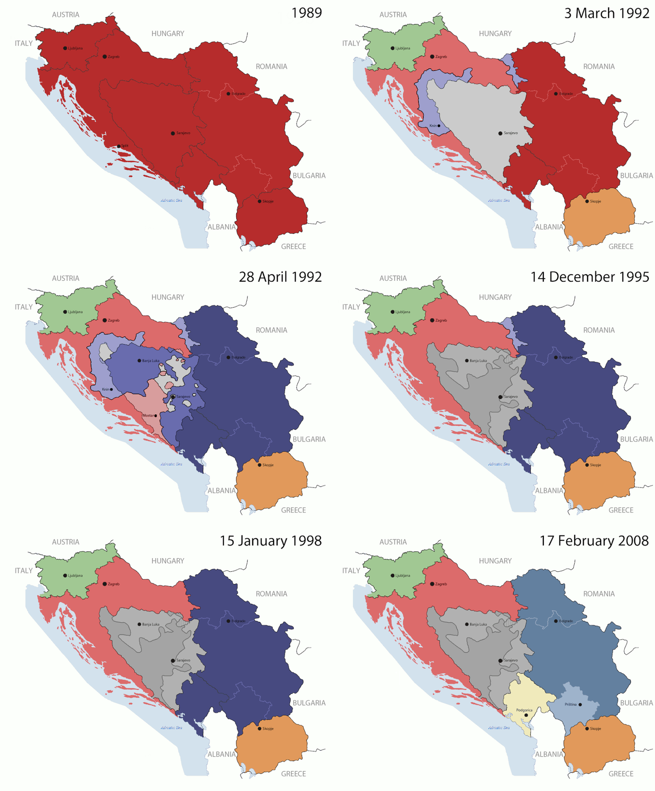
Изворна податотека (1.545 × 1.242 пиксели, големина: 187 КБ, MIME-тип: image/gif, кружно, 14 кадри, 44 с)

Врска до Ризницата Ова е податотека од Ризницата на Викимедија и може да се користи на други проекти. Подолу е наведена содржината на нејзината описна страница.
Заедничката ризница е складиште на слободно-лиценцирани слики и снимки. И Вие можете да помогнете.
This image could be re-created using vector graphics as an SVG file. This has several advantages; see Commons:Media for cleanup for more information. If an SVG form of this image is available, please upload it and afterwards replace this template with {{vector version available|new image name}}. It is recommended to name the SVG file "Breakup of Yugoslavia.svg" - then the template Vector version available (or Vva) does not need the new image name parameter.

Опис

Key:

Yugoslavia (1943–1992) SFR Yugoslavia
Croatia (1991–present) Croatia
Herzeg-Bosnia (1992–1994)
UNTAES (1996–1998)
Federal Republic of Yugoslavia / Serbia and Montenegro (1992–2006) Serbia and Montenegro
Republika Srpska (1992–present) Republika Srpska
Serbian Krajina (1991–1995/96)
Republic of Bosnia and Herzegovina (1992–1995)
Bosnia and Herzegovina (1998–present) Bosnia and Herzegovina
Western Bosnia (1993–1995)
Serbia (2006–present) Serbia
Kosovo (under UNMIK control 1999–present; declaration of independence 2008) Kosovo
Montenegro (2006–present) Montenegro
Macedonia (1991–present) Macedonia
Slovenia (1991–present) Slovenia


Опис

This is an animated GIF that shows the stages of the breakup of the SFR Yugoslavia in the 90's and 2000's. The map based off Morwen's map of the divisions of the SFRY, Which is licensed by the GFDL. The source for the dates of independence is the CIA World Factbook. These maps do not now show the Inter-Entity Boundary Line (IEBL) and/or the entities that are separated by it. The IEBL has been drawn based on this CIA map; the Brčko District has been drawn based on Image:BH municipality location.gif, by user:Ante Perkovic. I might add them in the future.

Since the original map was GFDL, this image is as well.

A map depicting Kosovo's final status is ready once it takes effect.


Changelog for versions 2/3:

Here are some changes in this new build of the map:

  • The Kosovo boundary has been given a shade of red instead of the previous UN blue since they are a province of Serbia under UNIMIK control.
  • Montenegro's color has been changed to a golden shade close to what's on the flag.
  • The IEBL and the Brčko District has been redrawn because I deleted the original map; the color for the Republika Srpska is lighter.
  • The dates are at the top left hand corner of the map instead of the bottom.
  • I have taken a new approach as to the boundaries. Each part of Yugoslavia now shows the boundary on the maps starting the year they broke away. I feel this change helps readers understand the breakup better.
  • The SFRY and the FRY are in different shades since the FRY was never accepted as the successor to the former by the UN.
  • The colors for the entities of BiH have been removed as to not confuse people into thinking that they are independent states. What remains is the IEBL with both entities in green.
  • The Kosovo boundary is finally in hash marks!
  • The Brčko District has been removed. The sale is too small to show accurately.

Changelog for version 4:

  • The map is larger!
  • The image has been rebuilt to include the eastern part of FYR Macedonia.
  • The image has been updated to take in Kosovo's new status.
  • The IEBL is now a darker line.
  • Montenegro, Kosovo, and FRY/SCG/Serbia have new colors!

Changelog for version 5:

  • Rebuilt
  • Larger map: size of base image
  • Accurate Inter-Entity Boundary Line
Датум 24 July 2006 (orginal upload date)
Извор Made by Hoshie; see above for more details on sources.
Автор Hoshie
Други верзии

Лиценцирање

GNU head Се дава дозвола за умножување, распространување и/или менување на овој документ под условите на ГНУ-овата лиценца за слободна документација, само Верзија 1.2 или било која понова верзија објавена од Фондацијата за слободна програмска опрема; без неменливи делови и без текстови на предни и задни корици. Примерок од лиценцата ќе најдете во делот наречен ГНУ-ова лиценца за слободна докуменација.
w:mk:Криејтив комонс
наведи извор сподели под исти услови
Оваа податотека е под лиценцата Криејтив комонс Наведи извор-Сподели под исти услови 3.0 Нелокализирана.
Можете:
  • да споделите – да го умножувате, распространувате и емитувате делото
  • да преработувате – да преработувате
Под следните услови:
  • наведи извор – Ќе мора да дадете прикладен припис, да ставите врска до лиценцата и да укажете дали има направено промени. Ова може да биде направено на било кој разумен начин, но без да оддава впечаток дека лиценцодавецот стои зад Вас и Вашата употреба.
  • сподели под исти услови – Ако го измените или преобразите делото, или пак ако основате друго дело на него, добиеното дело (придонесот) морате да го распространувате (објавувате) само под истата или складна лиценца на изворната.
Оваа ознака за лиценца е додадена на податотекава како дел од подновата на лиценците на ГЛСД.

Описи

Опишете во еден ред што претставува податотекава

Предмети прикажани на податотекава

прикажува

44 секунда

1.242 пиксел

1.545 пиксел

Историја на податотеката

Стиснете на датум/време за да ја видите податотеката како изгледала тогаш.

(најнови | најстари) Погледајте (понови 10 | ) (10 | 20 | 50 | 100 | 250 | 500).
Датум/времеМинијатураДимензииКорисникКоментар
тековна08:40, 17 јули 2016Минијатура на верзијата од 08:40, 17 јули 20161.545 × 1.242 (187 КБ)מפתח-רשימהReverted to version as of 17:22, 21 August 2015 (UTC)
18:22, 21 август 2015Минијатура на верзијата од 18:22, 21 август 20151.463 × 1.158 (1,81 МБ)BraganzaReverted to version as of 03:57, 19 January 2010
18:22, 21 август 2015Минијатура на верзијата од 18:22, 21 август 20151.545 × 1.242 (187 КБ)BraganzaReverted to version as of 01:02, 19 December 2011
18:15, 21 август 2015Минијатура на верзијата од 18:15, 21 август 2015120 × 95 (3 КБ)Braganza03:57, 19. Jan. 2010
02:02, 19 декември 2011Минијатура на верзијата од 02:02, 19 декември 20111.545 × 1.242 (187 КБ)DIREKTORAdded details
19:09, 27 јули 2011Минијатура на верзијата од 19:09, 27 јули 20111.545 × 1.242 (170 КБ)DIREKTORSmall fixes
18:28, 27 јули 2011Минијатура на верзијата од 18:28, 27 јули 20111.545 × 1.242 (171 КБ)DIREKTORAdded UNMIK
17:38, 27 јули 2011Минијатура на верзијата од 17:38, 27 јули 20111.545 × 1.242 (165 КБ)DIREKTORDates for the last two frames.
13:10, 27 јули 2011Минијатура на верзијата од 13:10, 27 јули 20111.545 × 1.242 (149 КБ)DIREKTORLighter shade for country names
17:59, 26 јули 2011Минијатура на верзијата од 17:59, 26 јули 20111.545 × 1.242 (170 КБ)DIREKTORHigher res plus details
(најнови | најстари) Погледајте (понови 10 | ) (10 | 20 | 50 | 100 | 250 | 500).

Глобална употреба на податотеката

Оваа податотека ја користат и следниве викија:

Погледајте ја останатата глобална употреба на податотекава.

Метаподатоци