Податотека:PIA19420-Mercury-NorthHem-Topography-MLA-Messenger-20150416.jpg

Изворна податотека (3.750 × 3.752 пиксели, големина: 3,49 МБ, MIME-тип: image/jpeg)
| Ова е податотека од Ризницата на Викимедија и може да се користи на други проекти. Подолу е наведена содржината на нејзината описна страница.
|
Опис
| Опис |
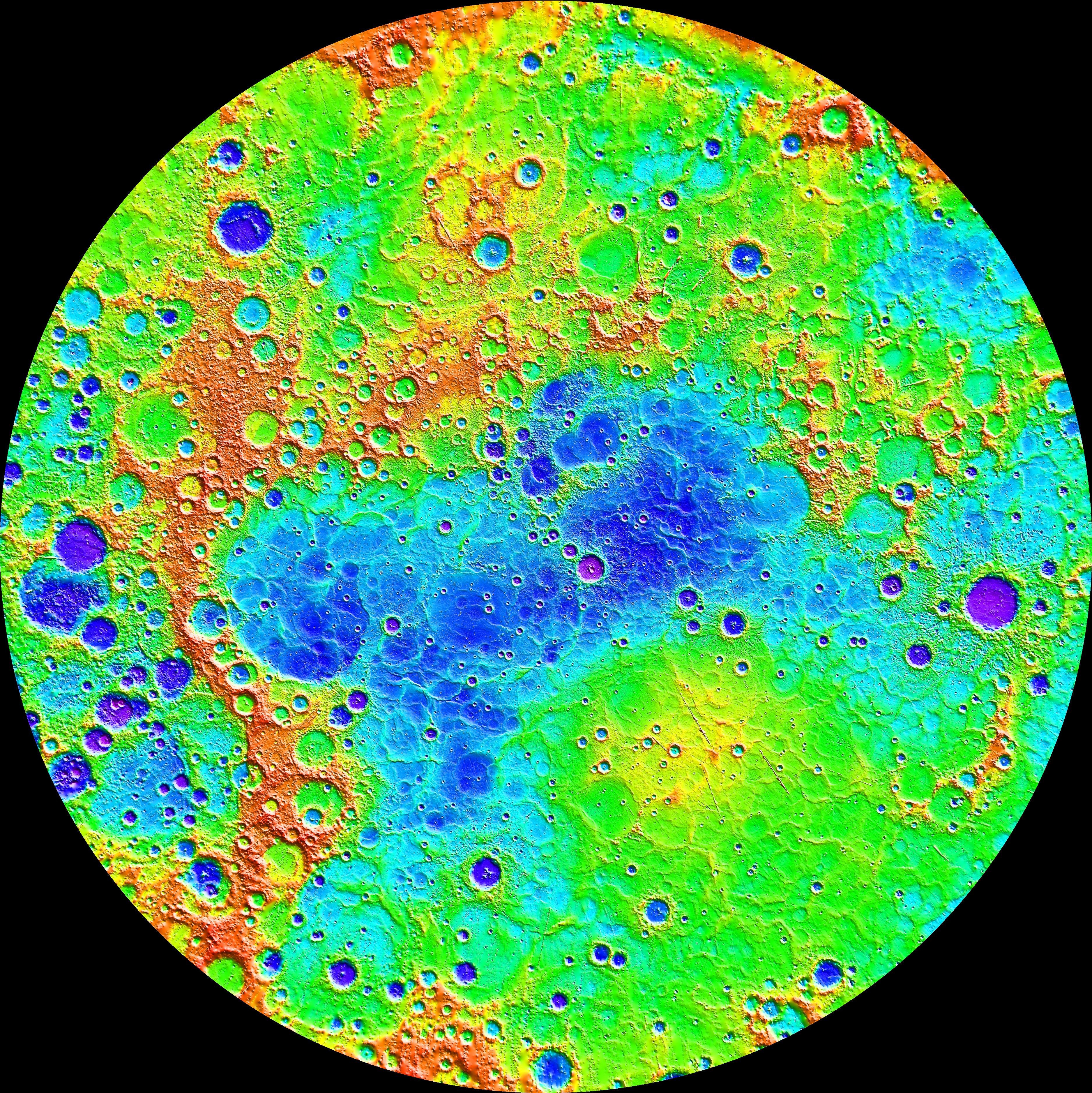
English: PIA19420: The Ups and Downs of Mercury's Topography
http://photojournal.jpl.nasa.gov/catalog/PIA19420 Measurements from MESSENGER's MLA instrument during the spacecraft's greater than four-year orbital mission have mapped the topography of Mercury's northern hemisphere in great detail. The view shown here is an interpolated shaded relief map of these data. The lowest regions are shown in purple, and the highest regions are shown in red. The difference in elevation between the lowest and highest regions shown here is roughly 10 kilometers! Among the prominent features visible here are the smooth northern volcanic plains and the enigmatic northern rise. The low-lying craters near the north pole host radar-bright materials, thought to be water ice. Linear artifacts can be seen in some areas of this map. These are due to individual MLA tracks that need minor adjustments in order to fit the rest of the data. Crossover analysis and better knowledge of the spacecraft position can be used to adjust these tracks and improve the map. Instrument: Mercury Laser Altimeter (MLA) Center Latitude: 90° Center Longitude: 0° E Latitude Range: 45° to 90° N The MESSENGER spacecraft is the first ever to orbit the planet Mercury, and the spacecraft's seven scientific instruments and radio science investigation are unraveling the history and evolution of the Solar System's innermost planet. In the mission's more than four years of orbital operations, MESSENGER has acquired over 250,000 images and extensive other data sets. MESSENGER's highly successful orbital mission is about to come to an end, as the spacecraft runs out of propellant and the force of solar gravity causes it to impact the surface of Mercury in April 2015. |
| Датум | |
| Извор | http://photojournal.jpl.nasa.gov/jpeg/PIA19420.jpg |
| Автор | NASA/Johns Hopkins University Applied Physics Laboratory/Carnegie Institution of Washington |
Лиценцирање
| Оваа податотека е во јавна сопственост бидејќи нејзин создавач е НАСА. Правилата за авторски права на НАСА велат: „Материјалот на НАСА не е заштитен со авторски права освен ако не е поинаку нагласено“. (Правилата за авторски дела на НАСА или правила за користење на слики од Лабораторијата за реактивен погон (JPL)). | ||
 |
Предупредувања:
|
| Прибелешки | Сликава има прибелешки: Погледајте ги на Ризницата |
Историја на податотеката
Стиснете на датум/време за да ја видите податотеката како изгледала тогаш.
| Датум/време | Минијатура | Димензии | Корисник | Коментар | |
|---|---|---|---|---|---|
| тековна | 14:56, 20 април 2015 | | 3.750 × 3.752 (3,49 МБ) | Drbogdan | User created page with UploadWizard |
Употреба на податотеката
Податотекава се користи во следниве 2 страници:
Глобална употреба на податотеката
Оваа податотека ја користат и следниве викија:
- Употреба на cs.wikipedia.org
- Употреба на en.wikipedia.org
- Употреба на en.wikiversity.org
- Употреба на et.wikipedia.org
- Употреба на eu.wikipedia.org
- Употреба на fr.wikipedia.org
- Употреба на it.wikipedia.org
- Употреба на ja.wikipedia.org