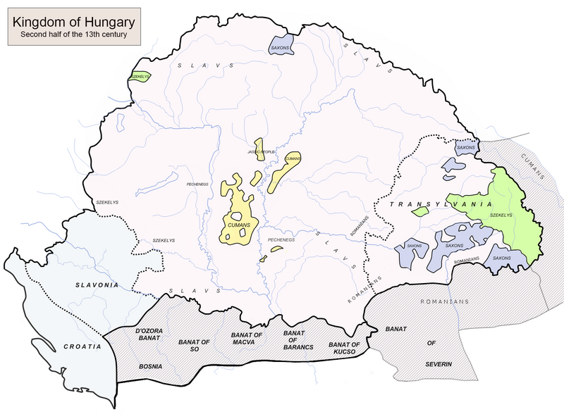
Податотека:Hungary 13th cent.png

Големина на овој преглед: 800 × 595 пиксели. Други разделности: 320 × 238 пиксели | 640 × 476 пиксели | 1.024 × 762 пиксели | 1.280 × 952 пиксели | 1.757 × 1.307 пиксели.
Изворна податотека (1.757 × 1.307 пиксели, големина: 451 КБ, MIME-тип: image/png)
Историја на податотеката
Стиснете на датум/време за да ја видите податотеката како изгледала тогаш.
| Датум/време | Минијатура | Димензии | Корисник | Коментар | |
|---|---|---|---|---|---|
| тековна | 20:17, 26 јули 2024 |  | 1.757 × 1.307 (451 КБ) | OrionNimrod | That is the original academic map as academic source: https://djnaploja.wordpress.com/wp-content/uploads/2015/11/magyar-kirc3a1lysc3a1g-xiii-sz.jpg |
| 10:31, 23 јули 2024 |  | 1.757 × 1.307 (356 КБ) | Shibbolet3579 | Restoration of the original map created 2008 by Fz22~commonswiki, without the nationalist negationism which intends to erase one of the communities from history (see talkpage) | |
| 19:15, 18 февруари 2024 |  | 1.757 × 1.307 (451 КБ) | OrionNimrod | I added the proper title, which is smaller and do not hide the north area. Following better borders, and put Pecheneg name only where I can see the original map | |
| 19:46, 7 мај 2021 |  | 1.757 × 1.307 (464 КБ) | ~riley | Reverted to version as of 11:16, 20 December 2019 (UTC) Post-edit war cleanup, consensus achieved at Special:Permalink/558633036#Ceha | |
| 23:22, 6 мај 2021 |  | 1.757 × 1.307 (458 КБ) | ~riley | Reverted to version as of 08:32, 27 April 2021 (UTC) | |
| 13:53, 3 мај 2021 |  | 1.757 × 1.307 (462 КБ) | Ceha | Reverted to version as of 13:26, 21 April 2021 (UTC) please look at the source http://www.historicaltextarchive.com/hungary/hu13.gif you are constantly puting Virovitica and similar towns out of Croatia | |
| 09:32, 27 април 2021 |  | 1.757 × 1.307 (458 КБ) | Mhare | Reverted to version as of 10:55, 21 April 2021 (UTC) please don't change if you do not have references. | |
| 14:26, 21 април 2021 |  | 1.757 × 1.307 (462 КБ) | Ceha | Reverted to version as of 20:47, 19 January 2021 (UTC), as stated in previous cases | |
| 11:55, 21 април 2021 |  | 1.757 × 1.307 (458 КБ) | Mhare | Reverted to version as of 11:42, 10 January 2021 (UTC) even that picture (which is without source anyway) has the borders as is in original picture, not the one you modified. | |
| 21:47, 19 јануари 2021 |  | 1.757 × 1.307 (462 КБ) | Ceha | Reverted to version as of 03:31, 4 January 2021 (UTC) Again, this http://www.historicaltextarchive.com/hungary/hu13.gif is the source |
Употреба на податотеката
Податотекава се користи во следнава страница:
Глобална употреба на податотеката
Оваа податотека ја користат и следниве викија:
- Употреба на ar.wikipedia.org
- Употреба на ba.wikipedia.org
- Употреба на bg.wikipedia.org
- Употреба на bn.wikipedia.org
- Употреба на cs.wikipedia.org
- Употреба на de.wikipedia.org
- Употреба на el.wikipedia.org
- Употреба на en.wikipedia.org
- Stephen V of Hungary
- March (territory)
- Ban (title)
- Béla IV of Hungary
- Kingdom of Hungary
- Cumans
- Transylvanian Saxons
- Great Hungarian Plain
- Portal:Hungary
- Germans of Romania
- User:Fz22
- History of Transylvania
- Vlach law
- Kunság
- Roman Catholic Diocese of Cumania
- History of Hungary
- Banate of Severin
- Duke of Transylvania
- Banate of Só
- Kingdom of Hungary (1000–1301)
- Second Mongol invasion of Hungary
- Theodore Vejtehi
- Henry I Kőszegi
- Template:Did you know nominations/Kingdom of Hungary (1000–1301)
- Judge of the Cumans
- Battle of Lake Hód
- Philip III, Bishop of Fermo
- Transylvanian Saxon University
- User:Falcaorib/Austria-Hungary
- Употреба на eo.wikipedia.org
- Употреба на es.wikipedia.org
Погледајте ја останатата глобална употреба на податотекава.