Податотека:East-Hem 200ad.jpg

Изворна податотека (3.240 × 1.903 пиксели, големина: 734 КБ, MIME-тип: image/jpeg)
| Ова е податотека од Ризницата на Викимедија и може да се користи на други проекти. Подолу е наведена содржината на нејзината описна страница.
|

|
Оваа слика (или сите слики од оваа страница/категорија) би требало бидат се преработи користејќи векторска графика со формат SVG. Тоа нуди неколку предности; видете „Податотеки за расчистување“ за повеќе информации. Доколку оваа слика веќе постои во SVG формат, тогаш подигнете ја. Откако ќе го направите тоа, заменете ја оваа предлошка со предлошката {{Vector version available|име на новата податотека.svg}}.
|


Опис
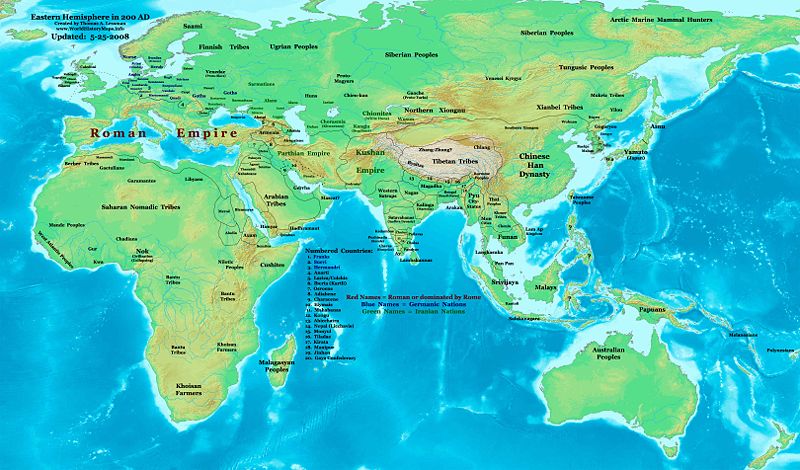
| Опис | Eastern Hemisphere in 200 AD. |
| Извор | self-made (For reference information, see the Map Source References section below.) |
| Автор | Thomas Lessman (Contact!) |
| Дозвола (Повторно користење на податотекава) |
Јас, праводржецот на ова дело, со ова го објавувам истото под следнава лиценца: Оваа податотека е под лиценцата Криејтив комонс Наведи извор-Сподели под исти услови 3.0 Нелокализирана.
|
| Други верзии |
Изведени дела од оваа податотека: Part of East Hem 200 AD.jpg see East-Hem_200ad.jpg file history on Wikipedia. |
Map Summary
Original Source URL: http://www.thomaslessman.com/History/images/East-Hem_200ad.jpg.
This map of the Eastern Hemisphere in 200 AD was created by Thomas Lessman, based on information from the sources listed below. This map is free for educational use (see Permission info above). When using this map, please mention that it is available for free at www.WorldHistoryMaps.info.
Map Source References
- Remember, sources often conflict with each other. This map is only as accurate as the information that is available to me. To report any errors or to help further this work, please click here, or email Thomas Lessman at talessman@yis.us
References for information contained in this map:
Primary Sources:
- 1. The DK Atlas of World History, 2000 Edition; map of The World in 250 CE, (Pages 46-47).
- 2. History and Commercial Atlas of China; map of Asia in 200 AD; available on Huhai.net.
- 3. Countries of the World, 1-1-136 CE архивски примерок на Wayback Machine map available on www.WorldHistoryMaps.com.
- 4. Map of the World in 200 CE, created by Wikimedia's User:Javierfv1212.
I - European Information is derived primarily from this Map of Europe in 200 AD from www.Euratlas.com.
II - Asian Information is derived primarily from:
- Han Dynasty borders are derived from the History and Commercial Atlas of China (see above, #2 under Primary Sources).
- Indian borders are derived from a combination of these sources:
- Wikimedia's map of the World in 200 CE, created by User:Javierfv1212.
- This map of the Countries of the World, 1-1-136 CE архивски примерок на Wayback Machine, available on www.WorldHistoryMaps.com.
- Wikimedia's map of Western Kshatrapas (Western Satraps), created by User:PHG.
- Wikimedia's Satavahana Map, created by User:PHG.
- Korean borders derive from this map of Korea-204.png made by Wikipedia User:Historiographer.
- Kushan Empire borders are derived from a mix of the sources below:
- The DK Atlas of World History (see above, #1 under Primary Sources).
- History and Commercial Atlas of China (see above, #2 under Primary Sources).
- Parthian Empire borders derive from:
- History and Commercial Atlas of China (see above, #2 under Primary Sources).
- Wikimedia's map of the World in 200 CE (see above, #4 under Primary Sources).
- Roman borders in Asia, along with borders for states in Iraq and Caucasus Mts, are derived from the Map of Europe in 200 AD from www.Euratlas.com.
III - African Information, and fringe areas like Australia, Siberia, etc. derive from:
- Wikimedia's map of the World in 200 CE, created by User:Javierfv1212.
- The DK Atlas of World History, 2000 Edition; map of The development of complex societies in Africa; (Page 160).
Note: Much of the information in this map was cross-checked with Bruce Gordon's Regnal Chronologies.
Other Maps by Thomas Lessman
| Maps of the eastern hemisphere showing history
Bold dates are available on Wikimedia or Wikipedia. | ||
| Primeval | ||
| Ancient
|
·| 600 BC | 550 BC | 527 BC | 500 BC |
400 BC | ·| 1 AD | 50 AD | 100 AD | 200 AD | 300 AD | | |
| Medieval |
·| 500 AD | 565 AD | 600 AD | 700 AD | | |
| Modern |
·| 1500 AD | · * For historical maps of the whole world, | |
Other Info
Историја на податотеката
Стиснете на датум/време за да ја видите податотеката како изгледала тогаш.
| Датум/време | Минијатура | Димензии | Корисник | Коментар | |
|---|---|---|---|---|---|
| тековна | 02:22, 26 мај 2008 | | 3.240 × 1.903 (734 КБ) | Talessman | Corrections to borders in West Asia, India, Southeast Asia, China, and Korea. Added more information based on new references. Other misc. corrections and updates. |
| 18:27, 9 мај 2008 |  | 3.240 × 1.903 (720 КБ) | Talessman | {{Information |Description=Eastern Hemisphere in 200 AD. |Source=self-made |Author=Thomas Lessman |Permission={{self|cc-by-sa-3.0}} }} |
Употреба на податотеката
Глобална употреба на податотеката
Оваа податотека ја користат и следниве викија:
- Употреба на ar.wikipedia.org
- Употреба на be-tarask.wikipedia.org
- Употреба на bg.wikipedia.org
- Употреба на bn.wikipedia.org
- Употреба на bs.wikipedia.org
- Употреба на ca.wikipedia.org
- Употреба на cv.wikipedia.org
- Употреба на de.wikipedia.org
- Употреба на el.wikipedia.org
- Употреба на en.wikipedia.org
- 3rd century
- 200
- Proto-Mongols
- History of Eurasia
- Chutu dynasty
- Talk:Odia language
- User:Tompw/sandbox10
- User:Talessman/Maps
- User talk:Talessman/Maps
- Timeline of ancient history
- Comparative studies of the Roman and Han empires
- User:Benjamin Trovato/sandbox
- Nagas of Padmavati
- List of Classical Age states
- User:Joelton Ivson/Gather lists/24978 – Os Romanos
- User:Falcaorib
- Achyuta of Panchala
- Употреба на en.wikibooks.org
- Употреба на en.wikiversity.org
- Употреба на eo.wikipedia.org
- Употреба на es.wikipedia.org
- Употреба на fi.wikipedia.org
- Употреба на frr.wikipedia.org
- Употреба на gl.wikipedia.org
- Употреба на he.wikipedia.org
- Употреба на hy.wikipedia.org
- Употреба на id.wikipedia.org
- Употреба на it.wikipedia.org
- Употреба на jv.wikipedia.org
- Употреба на ko.wikipedia.org
- Употреба на lv.wikipedia.org
- Употреба на ml.wikipedia.org
Погледајте ја останатата глобална употреба на податотекава.